For survey firms supporting grading and earthwork projects, the challenge isn't simply collecting another set of elevations. It's keeping up with a site that changes every day while giving contractors and project owners quantities they can confidently use.
Crews are already stretched. Schedules move quickly. Material is constantly being cut, placed, hauled, and compacted. When verification falls behind construction activity, discrepancies can become harder and more expensive to resolve.
A cut and fill map created through drone mapping services for surveyors can give firms a more efficient way to document those changes. Instead of treating earthwork verification as an occasional field event, firms can build a repeatable workflow to collect, process, verify, and deliver current site information throughout the project.
For the survey firm, the business value is straightforward: less time spent collecting repetitive site data, fewer unnecessary return visits, greater capacity for your existing team, and dependable documentation that helps clients make better decisions.
What Is a Cut and Fill Map?
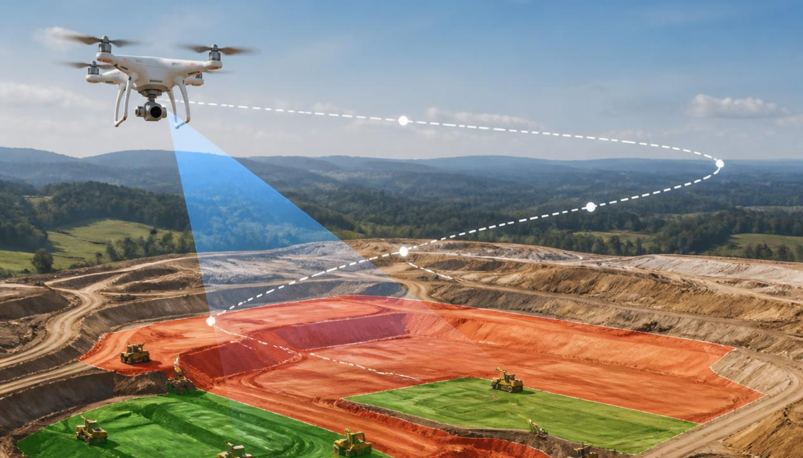
A cut and fill map compares two elevation surfaces to show where material has been removed and where material has been added.
Where the existing surface is higher than the proposed or comparison surface, material must be removed, or cut. Where it is lower, material must be added, or filled.
For an earthwork project, that comparison can help answer practical questions:
- How much material has been moved?
- Where is the site ahead or behind the planned grade?
- How much cut or fill remains?
- Are actual conditions matching the design?
- Has grading changed enough to affect quantities or project decisions?
That makes cut and fill analysis more than a visualization. Accurate earthwork quantities can influence project payments, estimates, schedules, inspections, and change-order discussions.
For a survey firm, dependable documentation also protects the integrity of your work. When questions arise about existing conditions, quantities, or progress, a consistent site record gives everyone something objective to work from.
How Drones Support Cut and Fill Verification
The value of a drone workflow starts with coverage.
Rather than collecting individual elevation points across a changing construction site, aerial mapping can capture dense site information and process it into an elevation surface. With appropriate control, checkpoints, flight planning, processing, and quality assurance, that surface can become the basis for earthwork analysis.
The workflow typically follows a repeatable sequence:
Plan → Collect → Process → Verify → Deliver
Plan
Define the project boundary, coordinate system, required accuracy, control strategy, deliverables, and comparison surface before collection begins.
Collect
Capture overlapping aerial imagery or other appropriate aerial data across the project area while following the established control and verification procedures.
Process
Convert the collected data into the appropriate geospatial products. Depending on the project, those may include orthomosaics, point clouds, digital elevation models, or terrain surfaces.
Verify
Review control, checkpoints, coverage, surface quality, and unusual site conditions before relying on the model for quantity calculations.
Deliver
Compare the current surface with the design grade, previous survey, or other approved reference surface and provide the resulting cut and fill information in a format the client can actually use.
This last point matters. A technically impressive model has limited value if the contractor, engineer, or project manager cannot incorporate the resulting information into the rest of the project workflow.
Understanding the Elevation Data Behind the Map
Not every elevation model represents the same thing.
A digital surface model (DSM) generally represents visible surfaces, including buildings, vegetation, equipment, stockpiles, and other objects.
A digital terrain model (DTM) is intended to represent the underlying terrain or bare-earth surface.
A digital elevation model (DEM) is a broader term for digital representations of elevation.
For earthwork verification, understanding which surface you are comparing is critical. Equipment, temporary materials, vegetation, or other site features can affect the model if they are not handled appropriately.
The comparison surface matters just as much.
A cut and fill calculation is only as useful as the two surfaces being compared. Your current site model might be compared against:
- Original ground
- Proposed design grade
- A previous survey
- A prior construction phase
- An approved grading surface
Before calculating quantities, everyone should understand what the comparison represents.
That simple discipline can prevent a technically correct calculation from answering the wrong business question.
Accuracy and Quality Assurance Matter More Than Speed
Drone mapping can make earthwork documentation more efficient, but speed should never come at the expense of confidence in the deliverable.
Ground control, checkpoints, positioning, image quality, flight planning, surface generation, and processing methodology can all influence the resulting data.
Current ASPRS Positional Accuracy Standards include guidance and best practices for UAS mapping, photogrammetry, lidar, ground control, and checkpoints. For survey firms, the practical lesson is to treat accuracy as a complete workflow rather than a single drone specification.
Before delivering cut and fill quantities, ask:
- Does the data meet the project's accuracy requirements?
- Were control and independent checkpoints handled appropriately?
- Is the correct surface being compared?
- Have equipment, vegetation, temporary stockpiles, or other site conditions affected the model?
- Can the process be documented and repeated?
- Can your client understand exactly what the quantities represent?
This is where quality assurance protects both your client and your margin.
Finding a problem before delivery is far less expensive than returning to the site, rebuilding the model, or explaining disputed quantities later.
Why Repeat Verification Can Create More Value
The biggest advantage may not come from replacing one traditional survey with one drone survey.
It comes from making repeat verification easier to incorporate into the project workflow.
Earthwork sites change continuously. If the workflow for collecting and processing current conditions is efficient and repeatable, survey firms can provide clients with more frequent visibility into project progress without tying up the same amount of field capacity each time.
That creates opportunities for:
- Progress verification
- Grading checks
- Quantity tracking
- Change documentation
- Material movement monitoring
- Historical comparisons
- Recurring project reporting
FHWA notes that accurate earthwork quantities are important to both agencies and contractors because they support project payments and digital inspection, and that small UAS can be used during construction to monitor earthwork quantities, including subgrade and final-surface quantities.
For a survey firm, that means cut and fill verification can become more than another deliverable. It can become a repeatable service your clients depend on throughout construction.
Reducing Field Exposure While Increasing Capacity
It also offers a practical workforce benefit.
Active construction sites contain moving vehicles, heavy equipment, changing grades, unstable surfaces, and other hazards. Reducing the time employees need to move through those areas physically can support a safer, more efficient collection process.
That does not eliminate the need for field control, verification, professional judgment, or appropriate site procedures. It changes where your skilled people spend their time.
Instead of using limited field capacity to manually collect every possible point, your team can focus more attention on control, validation, interpretation, and the final deliverable.
For firms dealing with staffing shortages and growing workloads, that distinction matters.
The objective isn't to replace the surveyor. It's to give the surveyor a more efficient way to complete the work.
Conclusion
A cut and fill map is valuable because it gives your client a clearer picture of what is actually happening on the site.
But the bigger opportunity for survey firms is the workflow behind it.
When earthwork verification becomes easier to collect, process, validate, and repeat, your team can provide more current information without continually adding field labor. That can mean fewer unnecessary return visits, earlier visibility into grading discrepancies, better documentation for quantity discussions, and more capacity to support additional projects.
The right drone workflow doesn't replace professional surveying judgment. It helps your existing team apply that judgment more efficiently.
If earthwork, grading, or construction verification is becoming a larger part of your project pipeline, book a call to review your current workflow, staffing capacity, and deliverable requirements. Together, we can identify where drone-based cut and fill verification can reduce rework, increase capacity, and help your firm confidently take on more work.